Royston (Iceni) Weather Station
News....from Royston (Iceni) Weather Station
Page 1
Items of interest and unusual occurrences concerning the Royston weather will be posted on this page. Reports of unusual or severe weather (e.g. ball lightning, funnel clouds, whirlwinds, heavy showers etc.), and any occurrences of hail and thunder, in or around Royston will be most welcome for inclusion on this page. Please e-mail any information to the station Met. Observer, Richard Barker, on rbarker@iceni.org.uk
| Period/Date | Weather Information |
| September 1999 | Warmest September since at least 1972 when records began at Royston (Iceni) Weather Station. The mean day maximum temperature was 2.7°C above the 25 Year (1993/1997) average at 21.3C, whilst the mean night minimum temperature of 12.6°C was 2.2°C above average. |
| 5th October 1999 | First ground frost of the Autumn (grass minimum temperature -0.5°C). |
| Autumn 1999 (September/November) | The mean daily maximum temperature of 15.5°C was the highest in Autumn since at least 1972. Taking the overall mean temperature it was only the warmest Autumn since 1995, however. |
| 14th December 1999 | First air frost of the Autumn/Winter season, but only with a minimum temperature of -0.1°C. The temperature had previously fallen to 0.0°C on both 18th November and 5th December but this does not count as an air frost. Lower lying parts of Royston may have experienced marginal air frosts on these dates. This is rather late for the first air frost, enabling summer bedding plants to survive longer than usual at the weather station. |
| 14th December 1999 | First snow of Winter! A light fall of snow in the late evening gave an 0.5 cm ground cover as measured at 09 GMT on 15th. |
| 20th December 1999 | Minimum temperature -4.5°C. Not a particularly low temperature but nonetheless the lowest temperature recorded since 1st February 1998 (-5.6°C), and lowest in December since 31st December 1996 (-7.2°C). |
| Year 1999 | Warmest year since 1990 with a mean temperature of 11.4°C. 1990 was only very marginally (<0.1°C) warmer. Since 1972 the 7 warmest years (mean temperature 11.0°C or above) have occurred within the last 11 years (a sign of recent global warming?). Rainfall in 1999 = 601.3 millimetres which is 103% of the 35 Year (1961/1995) average. An exceptionally sunny year with a sunshine total of 1705.3 hours, approximately 215 hours above normal. |
| 8th January 2000 | Highly luminous mock sun observed in Royston above the southern horizon about one hour before sunset. This mock sun, which was originally white, suddenly expanded and burst into a brilliant display of colour before fading away. A beautiful display of cloud effects in the afternoon sun added to a truly memorable event. |
| January 2000 | Another warmer than average month! The mean temperature was 1.1°C above average at 5.3°C, but it was still the coldest January since 1997. It was a dry month with total rainfall of 25.4 mm (50% of normal) and exceptionally sunny (86.8 hours, approx. 160% of average). |
| 1st February 2000 | Wettest day of the year so far. Rainfall 9.8 mm, not a significant amount of rainfall but an indication of the dry January. |
| 14th February 2000 | On average (25 years 1973/1997) the coldest day of the year in Royston.with a mean day maximum temperature of 5.4°C and a mean night minimum temperature of -0.3°C. This year's equivalent temperatures were 9.0°C and 0.0°C respectively so milder than average, particularly by day. |
| February 2000 | A very mild, very wet, and very sunny month! Mean temperature 6.7°C (2.6°C above 25 Year (1973/1997) average); rainfall 66.5 millimetres (191% of 35 Year (1961/1995) average); sunshine 114.8 hours (approx. 166% of normal). |
| 4th March 2000 | Coldest night of the year so far, although minimum temperature was only -2.0°C. This is more an indication of the mild January and February rather than a cold start to March, however. |
| 24th March 2000 | In the early hours a deposition of fine particles of orange/brown sand/mud occurred in Royston. This was washed out in light rainfall. These deposits are presumed to have originated from sandstorms in the Sahara Desert as a result of which the fine particles were carried aloft and transported northwards. The current synoptic situation is ideal for such an occurrence. |
| March 2000 | Mean temperature 1.6°C above 25 Year (1973/1997) average; rainfall 26% of 35 Year (1961/1995) average; sunshine approx. 110% of average (full details on Daily Weather Observations - March 2000 page). 7th consecutive month with above average sunshine. 31st month out of last 39 (since January 1997) with above average mean temperature. |
| 2nd/4th April 2000 | Although Royston does not appear to have received as much rainfall as several places in the Ouse valley to the north-west where flooding occurred (photographs River Ouse Floods - April 2000) , it has nonetheless been a wet start to April. In the 48 hours from 1800 GMT on 2nd to 1800 GMT on 4th it was actually raining for 41.4 hours! Much of this rainfall was fairly light, however; in this period a total of 34.1 millimetres rainfall was recorded. A hyetograph of this rainfall event can be viewed by clicking here. Rainfall - 2nd/4th April 2000 |
| 4th April 2000 | A very cold day for early April in Royston. The maximum temperature attained between 00 GMT on 4th and 00 GMT on 5th was only 3.1°C, and the mean temperature for the whole of this 24 hour period was only 2.3°C. A few brief snow and hail showers accompanied light rain. The day was completely sunless. |
| April 2000 | Wettest April since 1998 only, but 4th wettest (after 1998, 1919, and 1983) April in Royston since rainfall records commenced in 1853. Wettest month of any since September 1998. Mean temperature 0.4°C above average. Sunshine average, the first month since August 1999 not to have experienced above average sunshine. For full details of the April 2000 weather click on following link. Daily Weather Observations - April 2000 |
| 7th May 2000 | Light fall of orange/brown dust washed out in overnight rain. Probable origin North Africa (see 24th March 2000 above). |
| 15th May 2000 | Maximum temperature 26.0°C, warmest May day for 5 years (since 5th May 1995 when temperature reached 26.5°C). |
| 22nd/29th May 2000 | A month's rainfall in a week! The rainfall recorded from 09 GMT on 22nd May to 09GMT on 29th May totalled 48.0 millimetres, just 1.0 mm short of the 35 Year (1961/1995) average for the whole of May. To view a hyetograph of the week's rainfall click on the following link: Hyetograph - 22nd/29th May 2000 |
| 19th June 2000 | Maximum temperature 32.0°C; hottest June day since 28th June 1976 (32.6°C); hottest day in any month since 2nd August 1995 (32.6°C). |
| June 2000 | Another warmer than average month (34th such month out of 42 months since January 1997). Mean temperature 1.4°C above average; rainfall 41% of average; sunshine 94% of average. Warmest June since 1992; driest since 1996. For full details click on Daily Weather Observations - June 2000 . |
| 1st/4th July 2000 | July rainfall average reached by 4th July! Rainfall 1st/4th July = 48.9 millimetres which is 100% of the 35 Year (1961/1995) Royston average. |
| 1st/16th July 2000 | A very cool, very wet and very dull first half of July! The daily maximum temperature reached its 25 Year mean on only 2 days (2nd and 3rd) in this period , whilst the mean daily maximum temperature for 1st/16th was 4.0°C below average at 18.0°C. Rainfall 1st/16th July was 72.3 millimetres, which is 148% of the 35 Year average for the whole month, whilst sunshine in the first 16 days of July was only 34.9 hours against an average for the whole month of 186.0 hours (i.e. only 19% of the full month average). |
| July 2000 | A cool, dull and wet July. The mean daily maximum and minimum temperatures were 2.1°C and 0.7°C below average at 20.1°C and 11.8°C respectively. Rainfall was 74.3 millimetres (153% of average), whilst the total sunshine of 143.6 hours was only 77% of normal. It was the coolest July since 1988 and the wettest since 1987. It was also the 2nd very dull July in the last 3 years. |
| 3rd August 2000 | A fairly brief, but intense, shower occurred in the afternoon. The rainfall from this shower amounted to 8.4 millimetres, of which 5.7 millimetres fell between 1430 and 1435 GMT. This 5 minute value is a very high rate of rainfall indeed. The temperature dropped from 20.3°C at 1400 GMT to 14.3°C at 1455 GMT. Both thunder and hail were recorded during the shower. |
| 1st/16th August 2000 | In contrast to the first half of July, the first half of August has been warmer than average. The daily maximum temperature from 1st to 16th August exceeded its 25 Year (1973/1997) daily mean on 13 days, and the mean daily maximum temperature for this period was 1.0°C above average. The positive anomaly has been even greater by night - the mean night minimum temperature for the period 1st/16th was 2.0°C above average. It has been rather dry too with only 17.2 millimetres rainfall in the first half of August, but of greater significance is that only 21.2 millimetres rainfall has been recorded in the period 11th July to 16th August. This has been a good period for the harvest, which appears to be well on schedule in the Royston area this year. |
| 26th August 2000 | Deposition of light brown sand/mud in a light shower of rain in morning. Orange colour of deposits in previous falls this year on 24th March and 7th May absent on this occasion. Origin unknown, but probably North Africa. |
| August 2000 | Mean max. temp. 23.1°C (+0.9); mean min. temp. 13.3°C (+0.9); rainfall 43.3 mm (82%); sunshine 209.9 hours (118%). |
| Summer 2000 (June/August) | Mean max. temp. 21.3°C (-0.1); mean min. temp. 12.3°C (+0.6); rainfall 137.3 mm (92%); sunshine 537.3 hours (96%). |
| September 2000 | A warm and wet month with about average sunshine. Mean maximum temperature 19.7°C (+1.1); mean minimum temperature 12.2°C (+1.8); rainfall 78.2 millimetres (141%); sunshine 139.7 hours (97%). For full details click here. |
| 11th October 2000 | Lowest air pressure reading for 11 years. At 0345 GMT on 11th October 2000 the mean sea-level air pressure reached a low of 961 mb. This was the lowest air pressure value recorded since 25th February 1989, when a reading of 957 mb occurred. Both these values are extremely low for this part of the British Isles. (Click here for barogram). |
| 20th October 2000 | Wettest day for 5 years. Rainfall on 20th (i.e. 24 hours ended 0900 GMT on 21st) = 34.3 millimetres, making it the wettest day in any month since 16th September 1995 (44.0 millimetres), and the wettest October day since 2nd October 1982 (38.1 millimetres). Click here to view hyetogram of this rainfall event. |
| 21st October 2000 | Rainfall in year 2000 today reached the 35 Year (1961/1995) annual average (584.2 millimetres) for Royston. |
| 29th October 2000 | Another wet day! Rainfall in 24 hours ended 0900 GMT on 30th = 29.2 millimetres. This rainfall was accompanied by very strong winds and a maximum wind gust speed of 62 mph was recorded at 0505 GMT on 30th. Click here for hyetogram, and here for anemogram. |
| October 2000 | Wettest October in Royston since 1865. Rainfall 137.7 millimetres (275% of 1961/1995 average). Mean temperature 0.2°C above average; sunshine 100.9 hours (93% of average). For full details see Daily Weather Observations - October 2000 page. |
| 27th November 2000 | The rainfall (11.2 millimetres) measured today projected the Autumn (September/November) rainfall above the previous highest total (319.1 millimetres) recorded in Autumn 1974 to make Autumn 2000 the wettest Autumn in Royston since rainfall records began in 1853. |
| November 2000 | Mean temperature for month 7.6°C (0.5°C above 25 Year (1973/1997) average); rainfall 118.2 millimetres (225% of 35 Year (1961/1995) average (wettest November since 1970)); sunshine 84.6 hours (127% of 30 Year (1961/1990) average). For full details see Daily Weather Observations - November 2000 page. |
| 12th December 2000 | A very mild December night 11th/12th with a minimum temperature of 12.3°C. Other mild December nights since 1972: 03/12/1985 12.5°C; 18/12/1987 12.9°C; 22/12/1991 12.4°C; and 28/12/1994 12.3°C. Thus 12/12/2000 equal 4th mildest December night in last 29 years. |
| 13th December 2000 | A wind gust speed of 78 mph was recorded at 0205 GMT. This is the highest wind speed recorded in the last 3 years (since anemometer installed). Click here to view an anemogram of this event. |
| 26th December 2000 | A very late first air frost of the Autumn/Winter season at Royston (Iceni) Weather Station. Minimum temperature -1.0°C. |
| 29th December 2000 | First "ice day" (maximum temperature below 0°C) in almost 3 years. Maximum temperature -1.1°C. (Last "ice day" 10th January 1997). |
| December 2000 | Mean max. temp. 7.7°C (+0.6); mean min. temp. 4.3°C (+1.3); rainfall 66.7 millimetres (126%); sunshine 63.6 hours (135%). Click here for text report of December 2000 weather. |
| Year 2000 | Mean max.temp. 14.5°C (+0.7); mean min. temp. 7.6°C (+1.1); rainfall 821.0 millimetres (141%); sunshine 1562.2 hours (105%). Wettest year since 1958. |
| January 2001 | Mean max. temp. 5.6°C (-0.8); mean min temp. 0.9°C (-1.0); rainfall 59.6 millimetres (116%); sunshine 95.8 hours (177%). Coldest January since 1997, 4th consecutive sunnier than average January. For full details see Daily Weather Observations - January 2001 page. |
| 1st/7th February 2001 | Rainfall 1st/7th February 2001 = 59.0 millimetres, which is 169% of 30 Year (1971/2000) average for the whole month. |
| February 2001 | A very wet but sunny month, with a higher than average mean temperature, despite being the coldest February since 1996. Mean daily maximum temperature 8.2°C (+1.4); mean daily minimum temperature 1.8°C (+0.4°C); rainfall 90.7 millimetres (259%); sunshine 90.5 hours (131%). For full details see Daily Weather Observations - February 2001 page. |
| April 2000/March 2001 | Rainfall April 2000/March 2001 = 955.3 millimetres. Wettest 12 months ended March since at least 1853 when rainfall records began in Royston. |
| March 2001 | Mean temperature 5.9°C (-0.6°C); rainfall 87.2 millimetres (205%); sunshine 88.4 hours (82%). For full details see Daily Weather Observations - March 2001 page. |
| April 2001 | A dull and wet April. Although the mean temperature was equal to the 25 Year (1973/1997) average it was nonetheless the coldest April since 1989! Mean temperature 8.5°C (0.0); rainfall 74.0 millimetres (167%); sunshine 119.4 hours (84%). For full details see Daily Weather Observations - April 2001 page. |
| 28th May 2001 | Night of 27th/28th May the warmest in May since records began in 1972. Minimum temperature 16.3°C. |
| May 2001 | A dry month after a sequence of 8 wetter than average months. Rainfall 28.1 millimetres (60%); mean temperature 13.3°C (+1.5); sunshine 235.5 hours (122%). For full details see Daily Weather Observations - May 2001 page. |
| 25th June 2001 | Hottest and sunniest day of the year so far. Maximum temperature 27.0°C, reached at 1405 GMT; sunshine 15.73 hours. |
| 26th June 2001 | Maximum temperature 27.6°C (reached at 1305 GMT), slightly exceeding maximum on 25th (see above). |
| June 2001 | A second dry month (see 'May 2001' above). Mean temperature 15.2°C (+0.2); rainfall 21.0 millimetres (42%); sunshine 216.3 hours (111%). For full details see Daily Weather Observations - June 2001 page. |
| 7th July 2001 | End of dry spell. Rainfall 12.2 millimetres, after only 0.2 millimetres rainfall (on 29th June) between 17th June and 6th July inclusive. |
| 17th July 2001 | Rainfall 23.5 millimetres; wettest day for 9 months (since 20th October 2000 when 34.3 millimetres rainfall recorded). |
| 29th July 2001 | Maximum Temperature 30.9°C. First time 30°C exceeded in July since 17th July 1996. |
| July 2001 | Mean max. temp. 23.3°C (+1.1); mean min. temp. 13.6°C (+1.1); rainfall 59.3 millimetres (137%); sunshine 200.5 hours (108%). For full details see Daily Weather Observations - July 2001 page. |
| August 2001 | Mean max. temp. 22.9°C (+0.7); mean min. temp. 13.8°C (+1.4); rainfall 61.5 millimetres (124%); sunshine 196.9 hours (111%). For full details see Daily Weather Observations - August 2001 page. |
| September 2001 | A rather cool, dull and wet month. Mean max. temp. 17.4°C (-1.2); mean min. temp. 10.1°C (-0.3); rainfall 69.0 millimetres (121%); sunshine 112.2 hours (78%). For full details see Daily Weather Observations - September 2001 page. |
| 21st October 2001 | Exceptional rainfall event. Rainfall from 0405 to 2100 GMT on 21st October 2001 = 86.9 millimetres. This amount is split between the two "rainfall days" of 20th (51.8 millimetres) and 21st (35.1 millimetres). The rainfall amount on 20th (24 hours ended 0900 GMT on 21st) makes this the wettest day since 22nd September 1992 in Royston and the wettest October day in at least the last 30 years. The 20th was also the 3rd wettest day in any month in at least the last 30 years. Widespread flooding to north of Royston in Cambridgeshire. Click here to view a hyetogram of this event. |
| October 2001 | Wettest October in Royston since 1865 and wettest month of any since September 1995. Warmest October since at least 1972. Mean max. temp. 17.1°C (+2.8); mean min. temp. 11.4°C (+3.8°C); rainfall 137.8 millimetres (242%); sunshine 131.2 hours (121%). For full details see Daily Weather Observations - October 2001 page. |
| 10th November 2001 | First air frost of Autumn. Minimum Temperature -0.9°C. |
| November 2001 | A milder, drier and sunnier than normal November. Mean max. temp. 10.3°C (+0.8); mean min. temp. 5.0°C (+0.4); rainfall 42.3 mm (81%); sunshine 77.3 hours (116%). Mean temperature 6.6°C lower than in October. For full details see Daily Weather Observations - November 2001 page. |
| December 2001 | A cold, dry, and very sunny month. Mean max. temp. 5.8°C (-1.3); mean min. temp 1.1°C (-1.9); rainfall 22.7 millimetres (43%); sunshine 88.8 hours (189%). Coldest December since 1996; driest since 1991. For full details see Daily Weather Observations - December 2001 page. |
| January 2002 | A very mild month after a cold start; also dry and sunny. Mean Max. temp. 8.6°C (+2.2); mean min. temp. 4.4°C (+2.5); rainfall 33.2 mm (65%); sunshine 68.0 hours (125%). For full details see Daily Weather Observations - January 2002 page. |
| 26th February 2002 | Gale force winds affected the Royston area (and much of the country) during the morning of 26th February. Maximum gust recorded 65 mph @ 0605 GMT. Click here to view an anemogram of this event. |
| February 2002 | Mildest February since 1990; dullest February in at least the last 5 years, despite above average sunshine. Mean max. temp. 10.7°C (+3.9); mean min. temp. 4.9°C (+3.5); rainfall 48.9 millimetres (140%); sunshine 87.6 hours (127%). For full details see Daily Weather Observations - February 2002 . |
| (Continued on Page 2) |
|
|
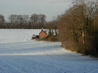
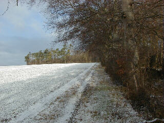
| Two views in bright sunshine taken from the line of the Greenwich Meridian (0° Longitude) at Burloes, Royston after a light overnight snowfall. The photograph on the left was taken at 0930 GMT on 15th December 1999 looking westwards; through the gap in the trees at centre the snow on Therfield Heath, some 2.5 km distant, is just visible. The second scene, pictured at 1007 GMT is about 1 km to the south of the first location and is viewed looking to the north from a position close to the B1039 road to Barley. |
Proceed to News....from Royston (Iceni) Weather Station page 2
Return to Welcome to Royston (Iceni) Weather Station header page
(This page last updated 1st February 2005 2115 GMT)