Royston (Iceni) Weather Station
Daily Weather Observations - November 2001
| Date | Max | Min | Grass | Earth | Sunshine | Rainfall | Wind | Mean | Max | Cloud | Mean | Mean | Mean | Fog | Fog | Snow | Snow | Hail | Thunder | Date |
| Temp | Temp | Min | (30cm) | (Hrs) | (MM) | Direc- | Wind | Gust | Cover | MSL | Rel. | Temp | (vis.< | (vis.< | or | Lying | 00/00h | 00/00h | ||
| (°C) | (°C) | Temp | Temp | 00/00h | 09/09h | tion | Speed | Speed | (Oktas) | Pressure | Humd | (°C) | 1000m) | 200m | Rain/ | (>50% | ||||
| 09/09h | 09/09h | (°C) | (°C) | 09h | (mph) | (mph) | 09h | (mb) | (%) | 00/00h | 09h | 09h | Snow | cover | ||||||
| 09/09h | 09h | 00/00h | 00/00h | 00/00h | 00/00h | 00/00h | 09h) | |||||||||||||
| 1 | 13.3 | 5.2 | 3.1 | 10.9 | 8.04 | 0.0 | W | 3.6 | 14 | 1 | 1038.7 | 83.5 | 7.9 | 0 | 0 | 0 | 0 | 0 | 0 | 1 |
| 2 | 14.5 | 7.1 | 4.3 | 10.0 | 3.32 | 0.0 | SW | 2.6 | 16 | 7 | 1040.3 | 80.6 | 9.7 | 0 | 0 | 0 | 0 | 0 | 0 | 2 |
| 3 | 13.3 | 6.8 | 4.1 | 10.0 | 7.88 | 0.0 | W | 2.6 | 14 | 0 | 1033.3 | 87.4 | 9.0 | 0 | 0 | 0 | 0 | 0 | 0 | 3 |
| 4 | 11.5 | 8.9 | 8.1 | 9.9 | 5.25 | 0.0 | W | 3.7 | 23 | 6 | 1025.0 | 82.7 | 9.3 | 0 | 0 | 0 | 0 | 0 | 0 | 4 |
| 5 | 10.6 | 2.8 | -0.6 | 9.5 | 6.25 | 0.1 | W | 4.4 | 32 | 0 | 1024.5 | 80.5 | 6.6 | 0 | 0 | 0 | 0 | 0 | 0 | 5 |
| 6 | 12.2 | 7.7 | 7.0 | 9.4 | 1.77 | 1.3 | W | 5.8 | 30 | 7 | 1013.7 | 83.3 | 10.3 | 0 | 0 | 0 | 0 | 0 | 0 | 6 |
| 7 | 12.0 | 9.0 | 7.7 | 9.9 | 0.19 | 7.9 | SW | 6.6 | 37 | 8 | 1008.2 | 91.1 | 9.7 | 0 | 0 | 0 | 0 | 0 | 0 | 7 |
| 8 | 4.9 | 3.8 | 2.0 | 10.0 | 0.00 | 4.5 | NW | 8.6 | 37 | 8 | 1003.6 | 85.6 | 3.9 | 0 | 0 | 1 | 0 | 0 | 0 | 8 |
| 9 | 5.4 | 0.1 | -0.5 | 8.6 | 2.90 | 0.3 | N | 3.9 | 30 | 7 | 1025.5 | 91.6 | 1.8 | 0 | 0 | 1 | 0 | 0 | 0 | 9 |
| 10 | 9.5 | -0.9 | -3.4 | 7.7 | 6.56 | TR | SW | 4.3 | 18 | 1 | 1030.3 | 83.3 | 4.2 | 0 | 0 | 0 | 0 | 0 | 0 | 10 |
| 11 | 13.1 | 6.9 | 5.2 | 7.8 | 0.44 | 0.7 | W | 3.9 | 16 | 8 | 1025.3 | 92.4 | 9.6 | 0 | 0 | 0 | 0 | 0 | 0 | 11 |
| 12 | 10.5 | 8.1 | 6.2 | 8.5 | 0.00 | 3.7 | SW | 4.1 | 28 | 8 | 1016.4 | 96.3 | 8.7 | 0 | 0 | 0 | 0 | 0 | 0 | 12 |
| 13 | 5.9 | 4.0 | 3.2 | 9.0 | 1.92 | 0.1 | N | 3.7 | 25 | 7 | 1026.1 | 88.0 | 4.0 | 0 | 0 | 0 | 0 | 0 | 0 | 13 |
| 14 | 6.2 | -0.9 | -3.5 | 7.9 | 3.43 | TR | NW | 1.0 | 14 | 0 | 1036.1 | 89.2 | 1.6 | 0 | 0 | 0 | 0 | 0 | 0 | 14 |
| 15 | 7.7 | -0.8 | -3.8 | 6.8 | 7.38 | 0.0 | CALM | 0.6 | 9 | 1 | 1040.1 | 89.9 | 2.9 | 0 | 0 | 0 | 0 | 0 | 0 | 15 |
| 16 | 9.4 | 5.6 | 5.4 | 6.6 | 0.00 | 0.0 | CALM | 0.0 | 5 | 8 | 1040.9 | 96.3 | 7.6 | 0 | 0 | 0 | 0 | 0 | 0 | 16 |
| 17 | 9.5 | 7.0 | 6.5 | 7.6 | 0.00 | 0.4 | CALM | 0.0 | 7 | 8 | 1035.1 | 92.6 | 7.6 | 0 | 0 | 0 | 0 | 0 | 0 | 17 |
| 18 | 8.5 | 6.5 | 5.0 | 8.0 | 0.00 | 0.6 | CALM | 0.4 | 14 | 8 | 1026.4 | 97.3 | 6.8 | 0 | 0 | 0 | 0 | 0 | 0 | 18 |
| 19 | 8.0 | 4.5 | 2.0 | 8.3 | 0.00 | TR | CALM | 0.0 | 7 | 7 | 1027.2 | 88.5 | 5.6 | 0 | 0 | 0 | 0 | 0 | 0 | 19 |
| 20 | 9.5 | 3.6 | 0.0 | 8.0 | 0.63 | 0.0 | SW | 4.7 | 18 | 8 | 1030.2 | 81.6 | 6.9 | 0 | 0 | 0 | 0 | 0 | 0 | 20 |
| 21 | 12.0 | 7.0 | 5.2 | 8.0 | 2.18 | 1.8 | SW | 11.7 | 39 | 1 | 1025.3 | 88.1 | 9.7 | 0 | 0 | 0 | 0 | 0 | 0 | 21 |
| 22 | 10.2 | 7.2 | 5.1 | 8.6 | 3.44 | 0.0 | NW | 7.3 | 35 | 7 | 1022.3 | 83.1 | 7.1 | 0 | 0 | 0 | 0 | 0 | 0 | 22 |
| 23 | 9.5 | -0.9 | -3.5 | 7.7 | 1.51 | TR | W | 3.3 | 18 | 7 | 1027.0 | 81.2 | 2.6 | 0 | 0 | 0 | 0 | 0 | 0 | 23 |
| 24 | 13.0 | 6.1 | 5.3 | 7.4 | 3.21 | 0.3 | W | 5.4 | 21 | 8 | 1022.6 | 91.1 | 9.8 | 0 | 0 | 0 | 0 | 0 | 0 | 24 |
| 25 | 13.5 | 9.9 | 7.9 | 8.3 | 0.01 | 3.0 | SW | 6.0 | 30 | 8 | 1016.1 | 94.3 | 9.3 | 0 | 0 | 0 | 0 | 0 | 0 | 25 |
| 26 | 7.4 | 2.5 | 0.0 | 8.3 | 6.96 | 0.0 | W | 2.7 | 14 | 0 | 1015.6 | 92.0 | 3.5 | 0 | 0 | 0 | 0 | 0 | 0 | 26 |
| 27 | 9.1 | 0.5 | -0.5 | 6.9 | 0.19 | 1.6 | S | 7.5 | 39 | 8 | 1007.8 | 93.0 | 4.4 | 0 | 0 | 0 | 0 | 0 | 0 | 27 |
| 28 | 11.3 | 3.8 | 1.5 | 6.7 | 3.72 | 6.4 | W | 7.4 | 25 | 2 | 1015.9 | 86.2 | 6.0 | 0 | 0 | 0 | 0 | 0 | 0 | 28 |
| 29 | 13.0 | 7.4 | 6.2 | 7.0 | 0.00 | 7.8 | SW | 7.7 | 32 | 8 | 1010.4 | 97.5 | 11.2 | 0 | 0 | 0 | 0 | 0 | 0 | 29 |
| 30 | 14.0 | 12.0 | 11.5 | 8.4 | 0.11 | 1.8 | SW | 6.9 | 30 | 5 | 1007.2 | 96.7 | 13.0 | 0 | 0 | 0 | 0 | 0 | 0 | 30 |
| Mean/Total | 10.3 | 5.0 | 3.2 | 8.4 | 77.29 | 42.3 | X | 4.3 | X | 5.4 | 1023.9 | 88.8 | 7.0 | 0 | 0 | 2 | 0 | 0 | 0 | Mean/Total |
| (+0.8) | (+0.4) | (116%) | (81%) |
Differences from average:
Differences from average shown in red. Reference periods used are as follows: Temperature 25 Years 1973/1997; rainfall 30 Years 1971/2000; sunshine 30 Years 1961/1990.
Observations procedure:
Note: In line with standard meteorological practice the 24 hour maximum temperature and rainfall are read at 0900 GMT and credited to the previous day i.e. data shown above for 1st actually read at 0900 GMT on 2nd and represents the previous 24 hours. The 24 hour minimum and grass minimum temperatures are similarly observed at 0900 GMT but are credited to the day of the reading (e.g. observations made at 0900 GMT on 2nd shown against 2nd and represent previous 24 hours). This is the reason why at daily update of the above table the minimum and grass minimum temperatures appear to be "ahead" of the other data mentioned. (This explanation given in response to a query received).
Graphs and Charts:
Click on the links below to view this month's graphs and charts........
1. Daily Maximum, Minimum & Grass Minimum Temperatures
2. Daily Maximum & Minimum Temperatures (with 25 Year Comparative Means)
3. Daily Earth (30 cms Depth) Temperature @ 0900 GMT 4. Daily Rainfall 5. Daily Sunshine
6. Daily Maximum Gust & Mean Wind Speed 7. Daily Wind Direction @ 0900 GMT
8. Daily Mean MSL Air Pressure 9. Daily Mean Relative Humidity
10. Thermograph 11. Barograph 12. Hygrograph 13. Anemograph 14. Wind Direction
15. Sunshine Duration 16. Rainfall Intensity & Duration
November 2001 Weather Review:
......... and for a text report of the November 2001 weather in Royston click on the following link
November (since 1972) at Royston (Iceni) Weather Station:
Mean day maximum temperature (25 years 1973/1997) 9.5°C
Mean night minimum temperature (25 years 1973/1997) 4.6°C
Highest temperature 17.8°C (2nd November 1984); lowest temperature -6.9°C (30th November 1978)
Lowest grass minimum temperature -10.5°C (30th November 1978)
Warmest November 1994 (Mean temperature 10.5°C); coldest November 1985 (Mean temperature 4.2°C)
Average November rainfall (30 years 1971/2000) 52.4 mm
Wettest November 2000 (Rainfall 118.2 mm); driest November 1978 (Rainfall 17.2 mm)
Wettest Day 12th November 1976 (Rainfall 28.0 mm);
Highest number of "rain days" (0.2 mm or more) 23 (1974); lowest number of "rain days" 7 (1978)
Highest number of days with thunder 2 (1974)
Highest number of air frosts 10 (1985, 1996)
Highest number of ground frosts 17 (1985, 1988)
Highest number of days with snow falling 4 (1980, 1985)
Highest number of days with snow lying (ground with more than 50% snow cover @ 0900 GMT) 5 (1988)
|
|
|
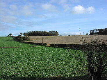
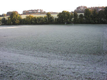
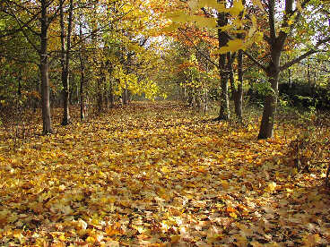
| This is the scene at Hyde Hill, Royston to the north of the A505 trunk road at 1241 GMT on 2nd November 2001. The sunshine in evidence and the state of the sky give a somewhat deceptive view of the pending weather as a few minutes later a cloud cover took over and there was no further sunshine that day (total sunshine 3.3 hours). However, the weather conditions were very pleasant at the time of the photograph with a reasonably mild temperature of 13.9°C and a light drift of air from a westerly direction, mean wind speed 3 knots, occasionally gusting to 8 knots. | The frost cover has yet to succumb to early morning sunshine (visible on Hyde Hill in the distance) and a rising temperature in this view of the Newmarket Road Playing Field, Royston at 0909 GMT on 15th November 2001. The overnight minimum temperature was -0.8°C (grass minimum -3.8°C), and the temperature had risen to 0.7°C at the time the photograph was taken. It later reached a maximum of 7.7°C for the day, and a sunshine total of 7.4 hours was recorded. It was virtually calm with only the slightest evidence of the occasional stirring of the air from the south-east. | Although the trees have shown a marked reluctance to shed their leaves this autumn (presumably due to the very mild October?) a colourful carpet of leaves has built up at this point on the Icknield Way about 1.5 km east of Royston, as seen at 0933 GMT on 21st November 2001. (The Icknield way is the prehistoric track which passes through Royston on its route between The Wash and the Salisbury Plain). It is rather breezy at this time with a SSW wind of mean speed 12 knots, gusting to 24 knots. The temperature is 9.1°C (after an overnight minimum of 7.0°C), later achieving a maximum of 12.0°C. |
Return to Welcome to Royston (Iceni) Weather Station page
(This page last updated 13th December 2001 2022 GMT)